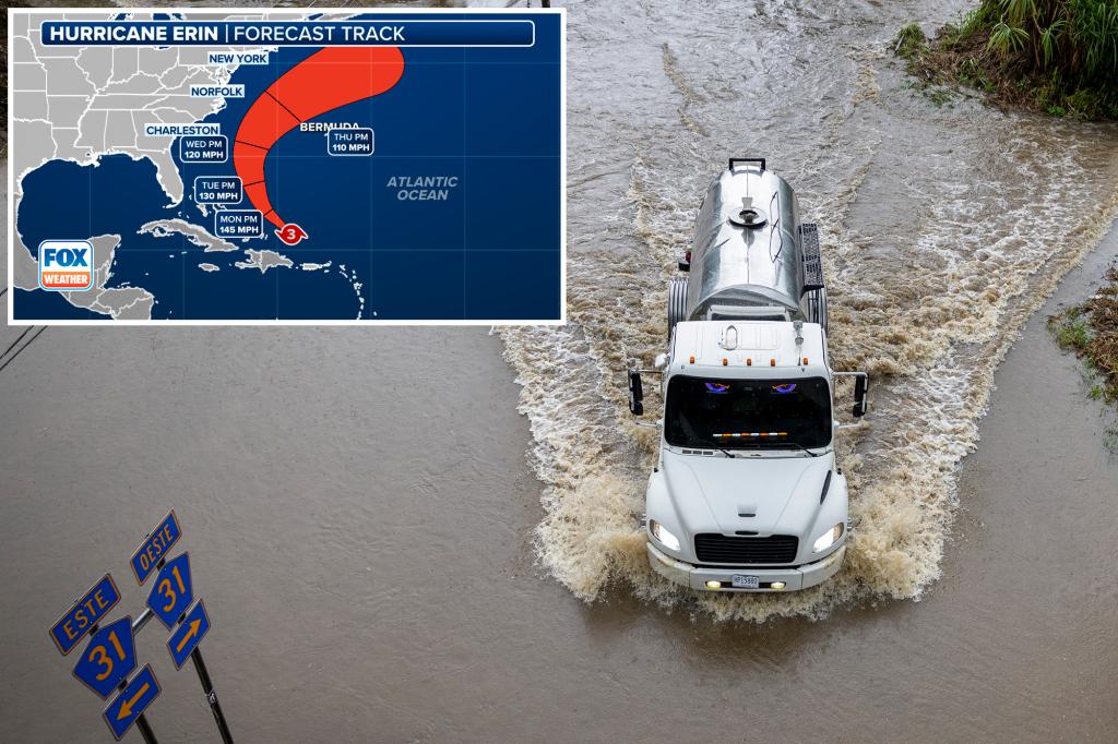
SAN JUAN, Puerto Rico – Hurricane Erin is likely to restrengthen again as it passes east of the Turks and Caicos Islands and the southeast Bahamas on Monday after lashing the Caribbean with damaging winds and flooding rain. Eventually, the National Hurricane Center (NHC) said Erin’s impacts will spread to the entire US East Coast with life-threatening beach conditions later this week.
Hurricane Erin, which became the first major hurricane of the 2025 Atlantic hurricane season, is no doubt going to be a storm for the history books. The powerful storm rapidly intensified over the weekend, going from a Category 1 hurricane to a catastrophic Category 5 hurricane with winds of 160 mph in a matter of hours.
While Erin is forecast to stay east of the US, impacts from this monster storm will be felt up and down the US East Coast, including on the Outer Banks of North Carolina. On Sunday, officials in Dare County ordered evacuations for Hatteras Island and declared a state of emergency for the entire county due to the “life-threatening impacts to the Dare County coastline.”
Over the weekend, ports were closed and flights were canceled, impacting travel, and local officials told residents to prepare for potentially life-threatening impacts from Erin as it brushed by the Caribbean islands.
As of the latest advisory from the National Hurricane Center (NHC), Hurricane Erin remains a major Category 3 hurricane with winds of 125 mph as the storm continues to move off to the west-northwest at 13 mph.
“Erin exhibited an eyewall replacement earlier today, with the eye diameter increasing from 5-10 n miles to around 40 n miles. If the replacement cycle completes, there should be a contraction of the eyewall by tonight,” the NHC wrote on Sunday evening. “This would likely result in another intensification episode.”
Hurricane Erin is also getting larger – hurricane-force winds extend about 25 miles from the storm’s center, and tropical-storm-force winds extend outward up to 205 miles.
“The hurricane will also grow in size,” FOX Weather Hurricane Specialist Bryan Norcross said. “As the circulation diameter gets larger, the peak winds normally diminish because the energy in the system is spread out over a larger area.”
Hurricane Erin is expected to continue to move off to the west-northwest on Sunday with a decrease in forward speed before a gradual turn to the north on Monday and Tuesday.
The center of Hurricane Erin is forecast to pass to the east of the Turks and Caicos Islands and the southeastern Bahamas on Sunday night and Monday.
Hurricane Erin is currently located about 275 miles to the north-northwest of San Juan, Puerto Rico, and about 165 miles to the east of Grand Turk in the Turks and Caicos Islands, where a Tropical Storm Warning is in effect.
A Tropical Storm Warning has been issued for the southeastern Bahamas.
While the Caribbean islands were spared a direct hit from the catastrophic impacts of Hurricane Erin, conditions remain extremely dangerous over Puerto Rico and the Virgin Islands as outer bands lashed the region with gusty winds and heavy rain.
The NHC said those outer bands will continue to impact the area on Sunday, and forecast rain totals of 3-6 inches, with isolated totals of up to 8 inches, are expected.
The National Weather Service office in San Juan has issued severe Flash Flood Warnings for the US Virgin Islands and Puerto Rico as the storm scoots by to the north.
So far, at least 9 inches of rain has fallen across Tortola in the British Virgin Islands, with Caguas and Camuy in Puerto Rico and St. Thomas in the US Virgin Islands picking up more than 2 inches of rain.
Local officials have urged residents to be aware of possible mudslides and landslides due to the relentless rounds of rain from Hurricane Erin’s outer bands that have been lashing the region.
Squalls with wind gusts to tropical-storm force could also occur over portions of the Virgin Islands and Puerto Rico on Sunday.
According to utility company LUMA, more than 150,000 power outages were reported across Puerto Rico as Hurricane Erin scooted by the island early Sunday morning.
“The adverse weather has caused multiple interruptions across the island,” the company said. “Our teams continue to work to address each situation as quickly and safely as possible.”
In addition, tropical-storm conditions are expected within the Tropical Storm Warning area in the Turks and Caicos Islands starting Sunday night, and in the southeastern Bahamas later Sunday night and Monday.
But it isn’t just the relentless rain and wind that could be life-threatening.
Ocean swells generated by Hurricane Erin will continue to affect portions of the Virgin Islands, Puerto Rico, Hispaniola and the Turks and Caicos Islands over the next few days.
Massive swells will spread to the Bahamas, Bermuda, the East Coast of the US and Atlantic Canada during the early to middle portion of the workweek.
Those rough conditions will also likely lead to life-threatening rip currents along East Coast beaches.
Will Hurricane Erin hit the US?
Some of Hurricane Erin’s impacts will be felt on the East Coast from Florida to New England, although a direct hit isn’t expected.
Coastal communities should be on alert for dangerous surf conditions producing massive waves and deadly rip currents through this week.
The National Weather Service office in Newport/ Morehead City issued a High Surf advisory and Coastal Flood Watch for parts of the Outer Banks, including west Carteret and coastal Onslow counties.
Large breaking waves between 10 and 15 feet are expected.
“The powerful hurricane will put a tremendous amount of energy into the ocean, which will be felt along all coastlines from the Caribbean to Canada, including the Bahamas and the US East Coast,” Norcross continued.

